
Background
Location
Unique Town Planning
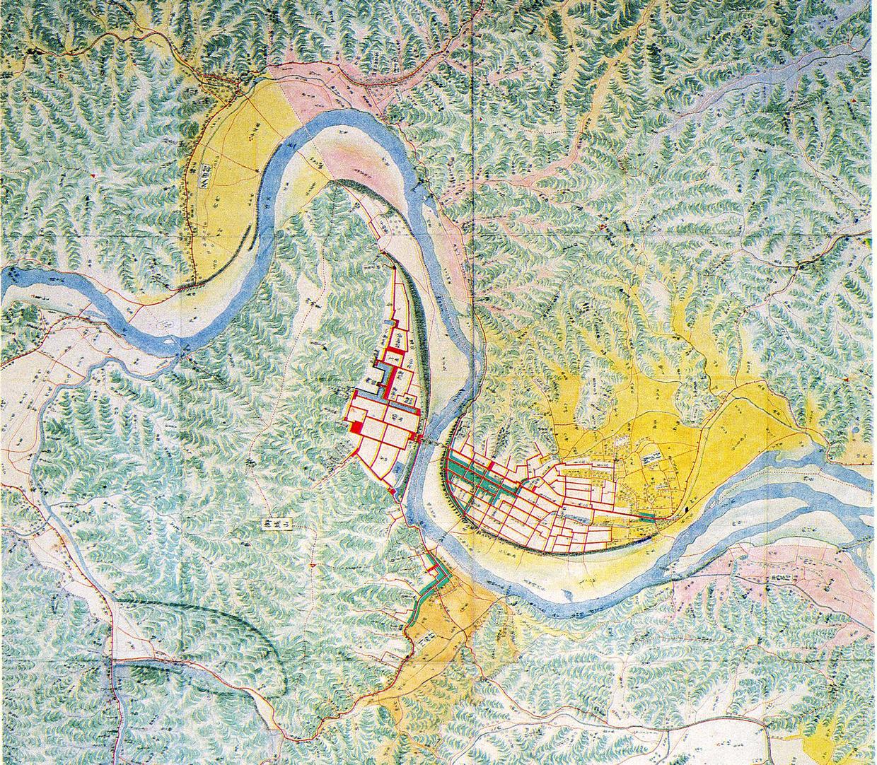 |
| Fig. 1: Map of Iwakuni Domain (1688) |
Immediately after defeat in the Battle of Sekigahara (1600), Hiroie Kikkawa, the first feudal lord of the Iwakuni Domain, planned to construct a strong castle town that would be easy to defend against the expected enemy attack. Having discovered that the Nishiki River flowed in a U curve around a mountain, the Lord Kikkawa decided to locate his castle on that mountain, since the River surrounding the mountain could serve as an ideal outer moat. At the foot of the mountain, he ordered upper-class warriors to build their residences. On the River’s opposite shore, the lord constructed a town for middle and lower-class warriors, as well as for the merchants who would support residents’ daily life. As a result, the castle town comprised two districts bisected by the River, which necessitated some means of linking the two districts.
 |
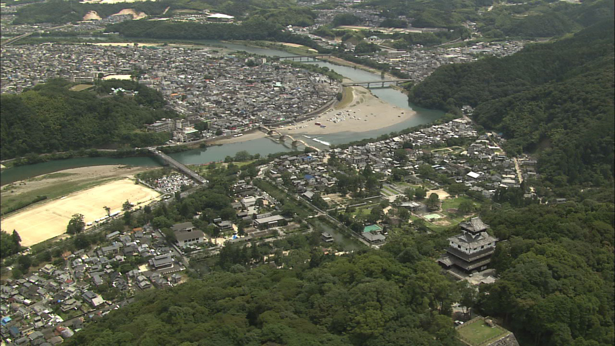 |
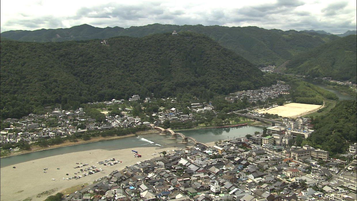
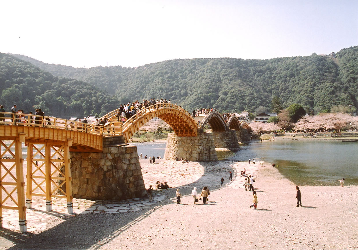
| Photo 1: Aerial photo of Kintaikyo Bridge and Mt. Shiroyama | Photo 2: Castle town viewed from Mt. Shiroyama |
Need for a Bridge
Although the original town plan conceived by Hiroie Kikkawa was excellent from the perspective of defense in war, which he believed would break out shortly, the area of land surrounded by the River was very narrow. Since not all his vassals were able to build their houses there, many were obliged to find land on the opposite shore. To assemble them at the castle for important decisions, a bridge was necessary, since only a bridge could ensure access for his vassals regardless of weather conditions. Accordingly, it is reasonably concluded that a bridge was constructed concurrently with the town. There is no evidence, however, that proves the existence of such a bridge at the time, since the oldest extant document indicating the presence of a bridge was written in 1639. However, this first known bridge, an ordinary girder bridge with many piers, was washed away by a storm. After losing the girder bridge, commuters to the castle used ferryboats for many years.
The ferryboat, however, was out of service whenever the water level became too high. During periods of continuous bad weather, vassals were unable to gather at the castle, a state that interfered with policy making and administrative procedures. It is in this context that people in Iwakuni were impatient to have a durable bridge that could withstand storms.
System for Guaranteeing the Bridge’s Long Life
In response to the growing demand for a durable bridge, the first Kintaikyo Bridge a five-span arch bridge was constructed in 1673. (The present Kintaikyo is the fourth.) For the initial 195 years, until 1868, the Kintaikyo Bridge was used only by successive feudal lords of the Domain and their vassals. Since 1868, however, local residents have been using the Kintaikyo Bridge as an essential means of crossing the River. Today, the bridge having been designated a national cultural property, the City of Iwakuni, home of the Kintaikyo Bridge, bears the responsibility of preserving the Bridge for present and future generations.
Despite the Bridge’s unique five-span arch structure, which is designed to enhance durability, the Kintaikyo, which is primarily made of wood, is vulnerable to natural disaster. As a way of long sustaining the Kintaikyo, the City of Iwakuni decided to establish a unique system: instead of reinforcing the existing Bridge structure, the City decided to guarantee the succession of Bridge building technology, so as to ensure repeated rebuilding of the Bridge. This solution is indeed unprecedented and unique in the history of bridges in the world.
Natural Disasters
Storms and Floods
The Nishiki River
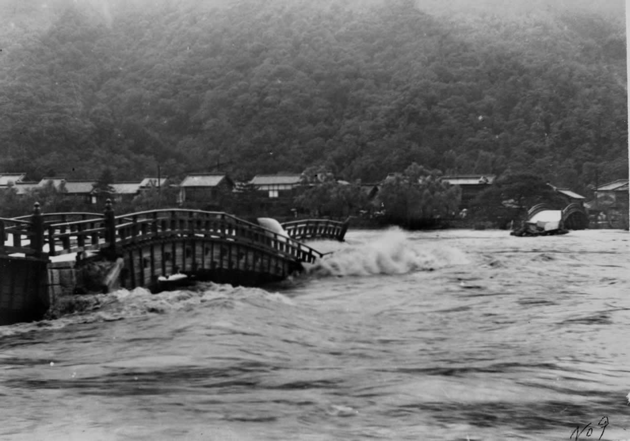 |
| Photo 3: An arch being washed away following the collapse of the fourth pier, due to the erosion of its stone footing |
The Nishiki River, spanned by the Kintaikyo, is Yamaguchi Prefecture’s longest river, with a total length of approximately 110 km and a total catchment area of approximately 884 km^2. (The River is 200-meter wide at the point of the Kintaikyo Bridge.) Today there are three dams upstream of the Kintaikyo, and an additional dam is under construction. In 1950, when the Bridge was washed away, however, there was only one dam (designed catchment area: 152.2 km2; total storage capacity: 7,031,000 m^3).
Collapse of the Bridge during the Showa Period (1926 - 1989)
 |
| Photo 4: The Nishiki River during dry season |
The Kintaikyo Bridge was washed away on September 14, 1950, when the River’s flow volume increased to 3,700 m^3/s at the point of the Bridge. This flow volume exceeded the design high water discharge of 2,470 m^3/s. Over the preceding two days, average precipitation in the catchment area had been 328.8 mm (Photo 3).
During the dry season (November to April), flow volume decreases as shown in Photo 4. Once flooding occurs, however, the water level rises as shown in Photo 3.
Heavy Rainfall
In 2005, Typhoon 14, which was formed between the night of September 6 and the dawn of September 7, 2005, brought heavy rainfall (maximum precipitation: 59 mm/hour) over the upper reach of the Nishiki River. The daily precipitation reached 472 mm, the heaviest rainfall in recorded history in Japan. At the observing station situated 600 meters downstream from the Kintaikyo Bridge, the water level reached 7.32 meters at 1:00 a.m. on September 7, as compared to the danger level of 6.4 meters. The flow volume at that time was approximately 5,400 m^3 /s (Photo 6), which was much greater than the level recorded when the Bridge was carried away in 1950. The heavy rainfall indicated that the three dams were insufficient to control flooding of the Nishiki River, thereby demonstrating the strategic importance of the Bridge design, including its spans(35.1m) and height of piers(6.6m).
Damage
The typhoon inflicted extensive damage on Kintaikyo Bridge. The drift from upper reaches destroyed two piers of the first span (Photo 7), causing damage to the fifth span as well (Photo 8). After the typhoon, approximately 40 million yen was needed to restore the Bridge. Damage inflicted on all of Iwakuni City amounted to approximately 14.8 billion yen.
 |
 |
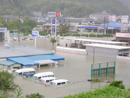
| Photo 5: A flood downstream of the Kintaikyo Bridge (for reference) |
Photo 6: The flood of September 2005 |
 |
 |
| Photo 7: The first span after losing two piers in the floor of 2005 |
Photo 8: Drift blocked the water flow under the fifth span |
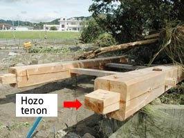 |
| Photo 9: Tapered hozo tenon, a design to enhance the ease of disjointing |
Despite the loss of the two piers from the first span, its superstructure remained intact. The superstructure was protected by the design of a special tenon called hozo (projection left by cutting away the wood around it for insertion into another member to make a joint) (Photo 9). Unlike typical tenons, which are designed to join members firmly, the hozo used in the Bridge had been tapered to allow members disjoint easily, so that substructural damage would not impact the superstructure. In other words, the hozo was designed to function in a way similar to a fuse in an electric circuit. This unique hozo design was developed over the long history of the Bridge, which experienced frequent storms and floods. Although the great flood of 2005 occurred 55 years after the similarly great flood of 1950, slightly less serious floods strike every few years. The Kintaikyo would have been carried away more frequently, had its central portion been a girder bridge equipped with many piers.
Earthquakes
In December 10, 1685 by the lunar calendar then in use (January 4, 1686 by the present solar calendar), the region was struck by an earthquake thought to have exceeded 7.0 on the Richter scale. A document of the time indicates that during the quake, piers submerged slightly. More recent earthquakes in the region include one measuring 6.9 on the Richter scale in 1905 and another measuring 6.2 in 1949. There is, however, no record that the Bridge was damaged by either quake.
Still more recently, the West Tottori Earthquake occurred on October 6, 2000 (7.3 on the Richter scale), and the Geiyo Earthquake on April 24, 2001 (6.4 on the Richter scale), both causing extensive damage to many structures in the nearby region. At the time of the Geiyo Earthquake, the Kintaikyo Bridge swayed so violently that pedestrians crossing it were extremely frightened. The Bridge, however, remained intact. The Bridge was free from deformation because the over 20,000 members comprising it absorbed the stress of the quake.
Thus, a storm definitely poses a greater threat to the Bridge than does an earthquake.